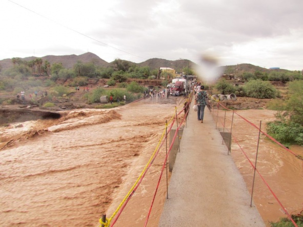
Any first hand reports on the previously mentioned detour for bridge construction? I and friends are crossing Thursday and Friday and would love to know if the alternate route is advised.
I always take the alternate route unless i'm very hungry or someone is then we'll stop at vasquez for food and tortillas, The sarape tacos stand that miramar likes does not open till later in the afternoon and that place is on the alternate road.
I crossed Monday afternoon heading back to the US. Traffic was being sent through one-way only alternating direction every 10-15 cars or so depending on traffic.
I had no problem crossing at 3 pm on Thursday going down as not one car was ahead of me coming up to the bridge. We stopped at Vasquez on the way home Monday afternoon and there was one wait for cars coming the other way with about five people ahead of us. Took about three minutes extra. I would avoid it during busier crossing times and take the short cut. We also ran into an army checkpoint on the way out of Penasco on Monday. For anyone going south there is also one at El Sahuaro south of the aduana and before the Santo Tomas turnoff.
I always take the alternate route unless i'm very hungry or someone is then we'll stop at vasquez for food and tortillas, The sarape tacos stand that miramar likes does not open till later in the afternoon and that place is on the alternate road.
The easiest way to tell you is go to the T intersection by the Circle K, turn right (if your hungry and if it's after 4:00, stop at El Serape Tacos on your left side after you make the right turn), make your first left and cross over the river then make a right at the stop sign. Continue down the street past the OXXO on the right. When you get to the stop sign, make a right, and you're back on the highway to Penasco by the police station.
No problems yesterday morning -- even though there was water standing in the streets in several areas. 2-way traffic crossing the bridge without delays.
However there was no power at the border crossing or at Organ Pipe. I would hope that's been restored by now.
Last Friday we still used the bypass, but it seemed the traffic was directed to make a left turn (going to Penasco) after the culvert at the corner of Benito Juarez onto September 16th. Then you're back on the regular road, Highway 2, make a right turn on Highway 8 and would pass by Vasquez. We chose a different route: made an immediate right turn after the culvert onto Miguel Hildalgo Y Costilla (beware of the speedbump), went down a couple of blocks, then made a left and then made a right on 16th of September until it hits Highway #8. That helped avoid the traffic.
Left Tempe at 11:30am Thursday. Finally checked in at 11:00pm Thursday night. Will post pics and explain Friday, too tired tonight. All I can say for now is have a vehicle that can swim and have a lot of patience. Washes in Arizona a 1 hour wait and Sononyta Crossing was a 6 hour wait and much more....
Left Tempe at 11:30am Thursday. Finally checked in at 11:00pm Thursday night. Will post pics and explain Friday, too tired tonight. All I can say for now is have a vehicle that can swim and have a lot of patience. Washes in Arizona a 1 hour wait and Sononyta Crossing was a 6 hour wait and much more....
Ed, I'll try to check in to see what you post, or you can send to me at rosie@proalliance.com.mx the info will be very useful for my radio show on Saturday. I foresee lots of calls and emails on this subject. Thanks in advance for any help you can give me.
Holy cow!! Sideways rain, thunder and lightning at Santo Tomas. Hoping the power doesn't go out this time. Zero visibility,make the sign of the cross at the river in Sonoyta. (this from my friend in Santo Tomas this morning
There are a series of about 5 washes 11.4 miles south of the 2nd border patrol stop, approximately 8-9 miles from Lukeville. We arrived at the first wash and were about the 10th car in line. It took about an hour when a BP vehicle finally went across. It was still ripping pretty good. I have an f350 that I thought was for sale but after this adventure I think I'm keeping it. We were also carrying about 1500 lbs of floor tile so I felt pretty good about going across. We were the first ones to cross the wash. Cars would have to wait longer. A lot of people turned around and went back. Spoke to a few who were considering heading out to Yuma and coming down coastal hwy. There were quite a few cars stuck between washes not able to go back or ahead. Lukeville had been hit pretty hard too as there was a lot of standing water all around the inspection stations. Sonoyta was a completely different story. The water was a river running down the side of the hill heading into town. As we made the turn heading towards the crossing we realized as we passed the Circle K we were not going to be going anywhere fast. We stopped right past the Circle K and stayed that way for 6 hours. (wasn't all bad as we found a new taco place to eat at) The electricity and water went off for maybe 2 hours more or less, not sure. Made it difficult if you hade to use a restroom. Circle K just closed theirs and locked the rest room doors. We spent the majority of our time going back and forth from the truck to the river checking on the progress and the flow of the river. It ended up being a huge event as people from town were coming to check things out all afternoon and night. Finally at about 9:15 pm a small dog crossed the river and then a couple of men went across and they started to let people cross. By now the line behind us was pretty long but the line on the 2 coming from the other way was so long we could not see the end of it. We were very lucky as the police let us on our side go first and after we passed through the intersection the police stopped our lane and let another lane go. I'm sure we would have been there for more than a few hours longer just trying to get across By the time our vehicle actually crossed the river the water was almost gone as if it were shut off at the main valve. There was still some flow but it was going under the road like it was supposed to.
Finally on the road again we headed on down to Rocky Point on the 8. Roads were wet not in bad shape at all. By now it was really dark and we were cruising at 80 mph. Saw some flashing blue lights ahead and slowed way down. It was not the police but one of the Green Angels who had stopped before a huge spot in the road where it was washed out. This was right before the big turn as you cross the river by the Cruz clinic and Pinacate reserve facility. If we would have hit that spot at 80.....who knows. Thank you Green Angel. After we crossed the river and made the turn heading south again we noticed the side of the road was really flooded and the water was moving at a good clip. It did not cause any problems for us and we continued on to RP. Finally we were approaching town and were planning on taking the right at the Laguna Shores- Caborca turn off. About 2 -3 miles before the turn traffic came to a stand still and it was all tractor trailers. The military was inspecting vehicles and opening each and every truck. If they (army) had not finally opened a second lane for passenger cars there is no doubt we would have been there for a couple hours. The trucks moved up one by one maybe every 10 minutes. When we finally maded the turn off we saw there was traffic stopped again. Not sure what was going on, if there was another inspection, accident , or what but we quickly turned around and came into town the old fashioned way. No one on the roads by now. Finally got to Sandy Beach at 11:15 and poured ourselves a few cocktails. A nice 12 hour adventure getting here. That's my story and I'm sticking to it. Sitting here having a coffee and it's raining right now.
Have some great pics but they're are taking a bit to upload. Check back later.
There are flash floods issued for the whole area. Not sure of the rain last night....I told my daughter who was scheduled to come down this afternoon to stay home. I feel alot more comfortable doing what I did in a F350. A small car just would just add more time to the whole ordeal. There's also a pretty good chance of having to deal with this on the return trip too. If I have to stay until it's clear I can. She has to be back on Sunday.
We had rain all night long here in Penasco last night. Not a roaring deluge but the kind gardeners love, a steady drizzle. Did not see lightening but the thunder was rooollling in 10 to 15 second rolls !
We had rain all night long here in Penasco last night. Not a roaring deluge but the kind gardeners love, a steady drizzle. Did not see lightening but the thunder was rooollling in 10 to 15 second rolls !
From here, we got a fine light show to accompany that thunder.
Debido a las lluvias, ayer viernes por la tarde se cayó un puente de los recién construidos en la carretera Sonoyta-San Luís R.C., esto sucedió a la altura del kilómetro 45 (mas o menos), por lo mismo trabajadores de la constructora construyen una desviación.
Será interesante saber quien asumirá el costo de su reconstrucción, se supone que la empresa constructora.See Translation
Bing Translator says : Sonoyta-San Luis R.C. Road, Brand new Bridge.
Thanks Jack...but that doesn't tell me where it is located...there is something about a 45km ........if this is between Sonoita and San Luis, that could put a damper on going around if the bridge in Sonoita is not passable using the Sonoita to San Luis route and then the Coastal Highway from El Golfo.....
Meanwhile, today (around 11:00) the detour bridge . . . err, ford . . . was overflowing again. A swift current to drive through, with a major backup (for southward traffic, anyway).
Thanks Jack...but that doesn't tell me where it is located...there is something about a 45km ........if this is between Sonoita and San Luis, that could put a damper on going around if the bridge in Sonoita is not passable using the Sonoita to San Luis route and then the Coastal Highway from El Golfo.....
Okay, Sunday morning. Anyone have an update on the road conditions? I'm fielding some calls and you guys are the fastest response team I've got. Please let me know so I can pass it along. Gracias!
Debido a las lluvias, ayer viernes por la tarde se cayó un puente de los recién construidos en la carretera Sonoyta-San Luís R.C., esto sucedió a la altura del kilómetro 45 (mas o menos), por lo mismo trabajadores de la constructora construyen una desviación.
Será interesante saber quien asumirá el costo de su reconstrucción, se supone que la empresa constructora.See Translation
Like · · =109703845771031&p[1]=845909"]Share · 37 minutes ago ·
Because of the rain, yesterday Friday afternoon fell a newly built bridge in the Sonoyta-San Luis R.C. Road, this happened at the height of the 45 kilometre (more or less), by the same workers of the construction company built a deviation.
It will be interesting to know who assumes the cost of reconstruction, it is assumed that the construction company.
I remember the road to Penasco back in the 80's....before they repaved it.....with several of the large dips, you could go airborne if you had enough speed!!!
Hi, did anyone crossed the sonoyta bridge today? Friday night we crossed the bridge and there was still 8-10in flash flood, we'll be coming back later today. Thanks!
Sorry, I have heard nothing from people crossing in the past day or so. There have been lots of storm clouds rolling up that way during the week. The sky is clear today no sign of storms to the north and east heading toward Sonoita today. Should be clear.
Crossed today at 2:00 p.m. - no traffic - water flowing underneath - the road leading down on both sides is getting torn to shreds = lots of semi trucks and with all the rain - the roads in Sonoita are getting pretty awful.
I noticed a large amount of semi trucks driving south and north today between RP and Sonoita - does this have to do with the bridge just collapsing between Sonoita and San Luis? Plus, it created a huge backup at the traffic circle just north of Penasco - the army was checking every car, including the trucks and there was a backup of maybe 25-30 trailer trucks (plus additional traffic) coming into Penasco. Looks like they are setting up a semi-permanent check point there - they've taken over what looks like an abandoned house and I saw a guy constructing a little taco/burrito shack nearby.
I noticed a large amount of semi trucks driving south and north today between RP and Sonoita - does this have to do with the bridge just collapsing between Sonoita and San Luis?.........
As far as I heard the heavy traffic was being detoured thru Penasco to take the El Golfo route as the bridge was in to bad of a shape to take semis, so that will be another cause for delays into PP however the semis traffic in Sonoyta should go down as they will not be taking mex#2 to Sonoyta any more until both bridges are fixed.
The backup in traffic was also caused by a big accident right at the El Golfo-Caborca juntion (as usual). My son and I drove by just after 1pm and the highway to and from Penasco was completely blocked by a semi and 3 cars. The ambulance had been and gone, but everyone was still waiting for the tow truck. Soldiers were helping divert traffic heading out of town at a very slow pace, but the line of (mostly semis) heading towards Penasco snaked for miles.
Does any of this effect the coastal highway route coming from either mexicali or yuma? I have friends from cali going to our condo and they are coming on coastal hwy. Thks!
The backup in traffic was also caused by a big accident right at the El Golfo-Caborca juntion (as usual).
That junction is one of the most poorly designed things I've ever seen and I've nearly been wrecked there twice -- just passing straight through to/from Penasco. Seems people get disoriented and lose their sense of right of way, or are confused and think they are going the wrong way. It's extremely dangerous; I always slow way down because you just never know what other drivers are going to do there.
I guess the diversion through Penasco wouldn't be bad if they weren't checking all the trucks - it creates a huge backup - then people start to make their own lanes and the it becomes a bit chaotic. I wish there was better traffic control.
I think trucks are normally prohibited from using the coastal highway but with that bridge on Highway 2 being out there is no alternative route when driving east or south from Baja/Tijuana/Mexicali. That is a major truck route. I would say there will be heavy truck traffic on the coastal highway until things dry out and they get a bypass road around that bridge. Repairs, or replacement probably will take a year !
The good part is that the coastal highway is wider and in better condition, should be fine with a little caution and slower traffic.
When I conduct tours to the Pinacate my guest are wondering why I put my flashers on and do like 25 mph through that piece of crap intersection
Is this the weird part of the road where you go right to Laguna Shores and the coastal highway or left to Caborca? Or am I thinking of the wrong place?
Melissa, You go left and circle the roundabout and then go right on the Caborca road. You have to cross the main road again to go left. That's where most of the wrecks happen, where the roundabout crosses the main road twice..... If I see anyone approachong or using the roundabout, I jst slow down til I see where they are going.....Stupid, stupid piece of engineering......
Melissa, You go left and circle the roundabout and then go right on the Caborca road. You have to cross the main road again to go left. That's where most of the wrecks happen, where the roundabout crosses the main road twice..... If I see anyone approachong or using the roundabout, I jst slow down til I see where they are going.....Stupid, stupid piece of engineering......
Okay, that's what I thought. In July when we left Sandy Beach via the new road when we got out to the highway it was really weird and we couldn't tell if we were on the correct side of the road or not trying to cross over to go north. I'm definitely going to be more careful there now! Thanks!
Sorry. I said left and I meant right. If you are going south, you turn right on the roundabout and circle it around to the Caborca turnoff and turn a soft right off the roundabout. You have to cross the main road south before getting to the turnoff. That's where most of the crashes are there. People heading north or south bound on the main road and people going around the circle get crashed into because they don't yield.....
Thanks to the link to the wunderground link posted here, we postponed our trip down from Thursday afternoon to friday morning. I watched the storm hang over sonoyta for an hour and said..nope manana. Crossed about 10am on fri without problems, they were just getting the rest of the wash out of the road south of Why as we went thru there. (MP70). Sunday morning at the detour they had a crew out clearing the debris from the culverts on the upstream and a backhoe dumping asphalt in the low spots on the edges. the water was still just cresting the pavement. Again thanks to the weather link, we got down safe, took care of business and pleasure and are new happy owners of a piece of Playa Encanto.
Also heading down this weekend so any reports would be nice. In the mean time, found this link. Shows watershed data for Rio Sonoyta North of border at 2 data stations. Now if someone can figure out how that correlates to wash in Sonoyta we would be able to forecast flows. The things we do to get to paradise......haha
Also heading down this weekend so any reports would be nice. In the mean time, found this link. Shows watershed data for Rio Sonoyta North of border at 2 data stations. Now if someone can figure out how that correlates to wash in Sonoyta we would be able to forecast flows. The things we do to get to paradise......haha
Any updates on the road in Sonoyta from anyone traveling through today (Friday Sept 7) would be appreciated. Heading down later this afternoon from Phoenix. Forecast looks like lots of rain for most of the day...
Came down yesterday, Miakko. Dry roads -- Even at the Sonyta bridge ("ford"). A new military checkpoint on the south end, enroute to Penasco, and then the usual checkpoint north of Penasco at the intersection. All is well.
A Port of Entry is any designated place at which a CBP officer is authorized to accept entries of merchandise to collect duties, and to enforce the various provisions of the customs and navigation laws (19 CFR 101.1).
SONOYTA DETOUR has a Facebook Page at Sonoyta Detour Updates | Facebook and it says the road IS CLOSED UNTIL FURTHER NOTICE - check it later to see any updates.
The border is open but the bridge is flooded. I had to run to the post office today and didn't make it. I did see lots of cars and trucks waiting around. I did see water flowing over their dumb little detour bridge. I did not see anything else out of the ordinary in Sonoyta. I hope to go again tomorrow as I really need to get to Lukeville ASAP. Please continue to post if you have updated information on the flooding situation. It looked like rain building this afternoon so I really hope that it is passable tomorrow.
We tryed to go through about 630pm and the wash was flowing they told us it would be at least 1 am before we could cross. we will try again in the am does anyone have a number to call for info
Will keep checking - also here are numbers to call: **Sonoyta Detour and “Wash Road” Report**
Lukeville Port of Entry (520) 387-5671 Sonoyta policia (011-52) 651-512-0192
I suppose the authorities should have shored up the detour route long before starting demolishion on the bridge. Shows a complete lack of planning. Maybe they just crossed their fingers and hoped for a very dry monsoon. If I were Penasco, I would be sending whatever help they can because this will be just another reason to deter people from coming down.
All the US Border Crossing is responsible for in terms of info is the status of the border crossing...not what is happening in town or any detours...yeah, it would be nice, and you occasionally might get some info...like if there was almost no traffic hitting the crossing heading to the US.
Maybe you can complain to the Mexican consulate...and get a sign put up at the border before you cross indicating the status of the detour????? :rofl::stir:
Has anyone done any exploring with 4WD from the border heading south (and east), on any of those dirt tracks that appear to lead down to Mexican HWY 8...Alvaro Obregon.... (?) east of town? Looking at a satellite view, there appear to be some dirt roads there......looks like you still have to cross the river.....east of town
Taking the coastal highway route (description from Nov 2011 JoinUs):
If crossing the border in Mexicali, there is a short toll road (12 pesos – about $1 US) to San Luis Rio Colorado. On the East side of San Luis Rio Colorado, as you go along Mexico Highway 2 signs begin to point to the Golfo de Santa Clara, which then leads to the Coastal Highway. The toll road down from San Luis RC to just north of Santa Clara was 94 pesos (about $7 US) the day we did this in August (2011), but is well worth the time saved and prevents hitting numerous speed bumps along the free road. Just past the toll booth (or before when heading North) there is sometimes a quick military check-point set up, so don’t be startled. Just before reaching the small town of Santa Clara (with a gas station on the right just as you enter town), the Coastal Highway stretches off to the left and begins its journey to Puerto Peñasco.
The trip along the Coastal Highway to Rocky Point from Santa Clara, El Golfo, takes just over an hour.
Has anyone done any exploring with 4WD from the border heading south (and east), on any of those dirt tracks that appear to lead down to Mexican HWY 8...Alvaro Obregon.... (?) east of town? Looking at a satellite view, there appear to be some dirt roads there......looks like you still have to cross the river.....east of town
There is a road that connects Highway 8 to Highway 2 through the Pinacate. It's a couple of miles outside of Sonoita on 2. You would enter (or exit) 8 at the gated entrance to the Pinacate where you pay. I have driven it in the past. It's rough in the best times and probably washed out with all the rain. Might make it in a rock crawler 4x4. It would be a fun drive with a couple of vehicles.
You just can't keep the Penasco lovers away ! Just visited with some folks who crossed at Sonoita and drove Mex 2 to Mexicali then down the coastal highway ! The did not have any problem from that reported bridge collapse on 2, said they did not see it. Said they were in an informal convoy of AZ plated vehicles and hit some 5 miltary stops along the way, but they are here and having a great time. I suggested they avoid Mex 2 on the way back and they agreed !!
Weather radar is showing some rather large storms heading toward Sonoyta as we speak. Hopefully they may break up.
It looks like they may extend all the way up to Why or there abouts. I think some may have an extended weekend down there.
Lucky dogs. I hope it clears out and they get that mess cleaned up in the next 11 days 'cause that's when I'm headed down
to terrorize the Puerto Penasco Police Department.